Indus Valley Civilization: Origin, Sites, Town Planning, and Decline
Introduction
The Indus Valley Civilization (IVC), also known as the Harappan Civilization, represents the earliest known urban culture on the Indian subcontinent. Belonging to the Proto-Historic Period (a period with a written script that remains undeciphered), it flourished alongside ancient contemporary civilizations such as Mesopotamia, Egypt, and China.
Discovered in the early 1920s, the Indus Valley Civilization is renowned for its advanced urban planning, sophisticated drainage systems, flourishing maritime trade, and standardized weights and measures.
Chronology and Phases of Development
Based on radiocarbon dating (C14), the Harappan culture developed through three distinct chronological phases:
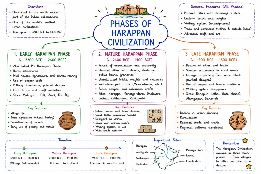
- Early Harappan Phase (3300 – 2600 BCE): Formative stage marked by agricultural settlements, early trade, and village networks (e.g., Kot Diji, Amri, Kalibangan).
- Mature Harappan Phase (2600 – 1900 BCE): Peak urban civilization characterized by planned cities, advanced drainage, specialized crafts, and long-distance trade.
- Late Harappan Phase (1900 – 1300 BCE): Period of gradual decline, urban decay, and migration toward eastern and southern regions.
Geographical Extent
The Indus Valley Civilization covered an immense triangular area of nearly 1.3 million sq km, making it significantly larger than ancient Egypt and Mesopotamia combined.
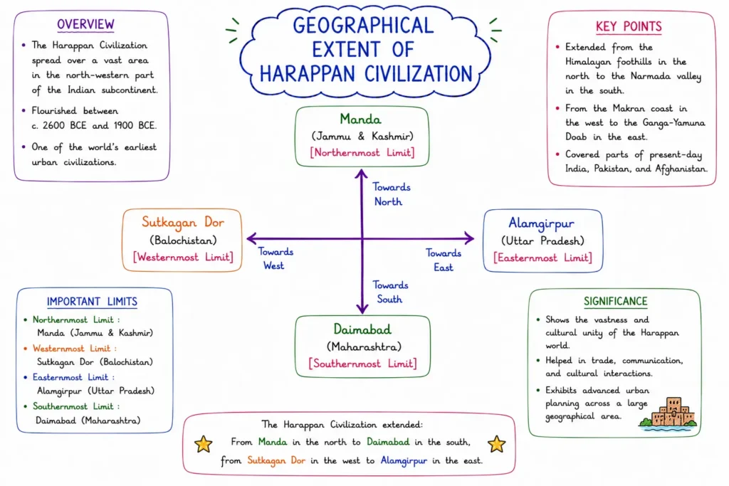
- Northern Boundary: Manda (on the banks of the Chenab River, Jammu & Kashmir).
- Southern Boundary: Daimabad (on the banks of the Pravara River, Maharashtra).
- Eastern Boundary: Alamgirpur (on the banks of the Hindon River, Uttar Pradesh).
- Western Boundary: Sutkagan Dor (on the Dasht River, Pakistan-Iran border, Balochistan).
Salient Features of Harappan Civilization
1. Advanced Town Planning
Town planning was the most distinctive feature of Harappan urban life, demonstrating centralized municipal control:
- Grid System: Cities were laid out on a systematic grid pattern, where main streets crossed each other at right angles (90∘), dividing the settlement into rectangular blocks.
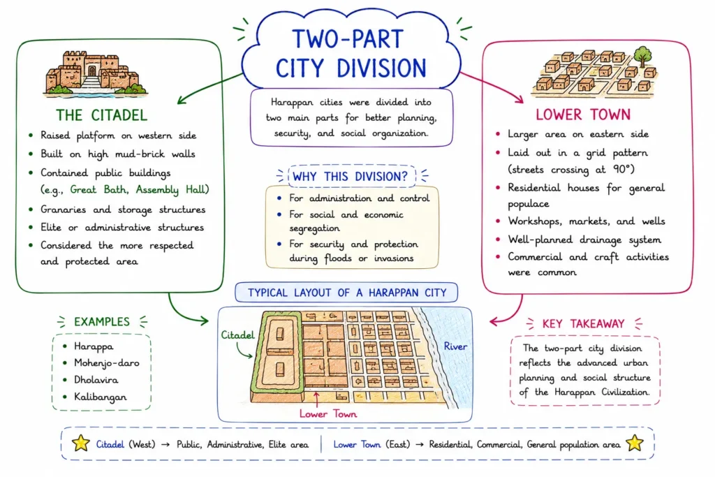
- Two-Part City Division: Most major cities were divided into two fortified sectors:
- The Citadel (Raised Upper Town): Located on the western side, built on a mud-brick platform. It housed administrative structures, public buildings, and residences of the ruling class.
- The Lower Town: Located on the eastern side, larger in area, housing the general population, artisans, and merchants.
- Building Materials: Buildings were constructed using standardized baked (burnt) bricks with a uniform ratio (1 : 2 : 4 in thickness : width : length), set in gypsum or lime mortar.
- Subterranean Drainage System: Every house was connected to a covered street drain. Drains were constructed using brick or stone slabs and were equipped with inspection manholes at regular intervals for cleaning—reflecting an exceptional focus on public health and sanitation.
2. Economic Life: Agriculture and Trade
- Agriculture: The primary economic base. Crops were grown in fertile floodplains. Major crops included wheat, barley, mustard, sesame, cotton, and peas. Harappans were the earliest people in the world to produce cotton (known to Greeks as Sindon).
- Domestication of Animals: Cattle, buffaloes, sheep, goats, pigs, and dogs were domesticated. Evidence of horses is controversial, though horse teeth/bones were discovered at Surkotada.
- Trade and Commerce: Extensive internal and international trade networks existed.
- Imports: Copper (Khetri mines, Rajasthan & Oman), Gold (Kolar, Karnataka & Afghanistan), Lapis Lazuli (Badakhshan, Afghanistan), Steatite (Iran).
- Exports: Cotton goods, pottery, ivory products, timber, and beads.
- Mesopotamian Records: Mesopotamian texts refer to trade with Meluha (the ancient name for the Indus region). Intermediate trading ports mentioned include Dilmun (Bahrain) and Magan (Oman).
3. Social and Religious Life
- Social Structure: A prosperous merchant class held significant social influence. Society was stratified into rulers/priests, merchants, artisans, and manual laborers.
- Religious Practices:
- Mother Goddess Worship: Numerous terracotta figurines of pregnant women or mothers signify fertility cults.
- Pashupati Mahadeva (Proto-Shiva): A seal depicting a three-faced seated deity surrounded by animals (elephant, tiger, rhino, buffalo, and two deer at his feet).
- Nature Worship: Worship of trees (specifically the Peepal tree), animals (humped bull), and symbols (Swastika, Yoni, and Lingam).
- No Temples Found: Unlike Egypt or Mesopotamia, no monumental public temples or religious structures have been discovered in the Indus Valley.
- Harappan Script: Pictographic script containing around 375 to 400 signs. It was written in a Boustrophedon style (alternating lines from right-to-left and left-to-right). The script remains undeciphered to this day.
Major Harappan Sites and Key Discoveries
| Site | Location & River | Excavator (Year) | Key Discoveries / Features |
|---|---|---|---|
| Harappa | Sahiwal, Punjab (Pakistan) (River Ravi) | Daya Ram Sahni (1921) | • 6 Granaries in a row • Stone symbols of Lingam and Yoni • Mother Goddess figurines • Copper scale |
| Mohenjo-Daro (Mound of the Dead) | Larkana, Sindh (Pakistan) (River Indus) | R. D. Banerji (1922) | • Great Bath • Great Granary (largest structure) • Bronze Dancing Girl statue • Steatite Bearded Priest • Pashupati Seal |
| Lothal | Ahmedabad, Gujarat (River Bhogava) | S. R. Rao (1954) | • Artificial Dockyard (world’s oldest) • Double burial (Male & Female) • Rice husk evidence • Persian button seal |
| Kalibangan (Black Bangles) | Hanumangarh, Rajasthan (River Ghaggar) | A. Ghosh (1953) / B. B. Lal (1961) | • Ploughed field surface (earliest evidence) • Fire altars (Yajna Kunds) • Camel bones • Decorative bricks |
| Dholavira | Kutch, Gujarat (Rann of Kutch) | R. S. Bisht (1990) | • Three-tier city division (Citadel, Middle Town, Lower Town) • Advanced Water Management System (reservoirs) • Large Signboard with 10 symbols |
| Chanhudaro | Nawabshah, Sindh (Pakistan) (River Indus) | N. G. Majumdar (1931) | • Only Harappan city without a Citadel • Industrial hub for Bead-making • Evidence of lipstick and cosmetics |
| Banawali | Fatehabad, Haryana (River Saraswati) | R. S. Bisht (1974) | • Terracotta model of a plough • High quality barley seeds • Oval-shaped settlement design |
| Rakhigarhi | Hisar, Haryana (River Ghaggar) | Amarendra Nath (1997-2000) | • Largest Harappan site in India • Extensive cemetery and granary structures |
Decline of the Indus Valley Civilization
Around 1900 BCE, the mature phase of the civilization began to fade. Historians propose several theories for its decline:
| Proposed Theory | Primary Proponents / Scholars | Key Evidence & Arguments |
|---|---|---|
| Aryan Invasion Theory | Sir Mortimer Wheeler, Gordon Childe | Discovery of human skeletons lying unburied at Mohenjo-Daro (later largely discredited). |
| Ecological Imbalance / Climate Change | Wheeler, Fairservis | Over-exploitation of forests, overgrazing, and soil salinization led to desertification. |
| Tectonic Shifts & River Course Changes | H. T. Lambrick, M. S. Vats | Tectonic uplifting blocked rivers, leading to severe flooding or drying up of the Ghaggar-Hakra river system. |
| Catastrophic Floods | M. R. Sahni, Robert Raikes | Silt deposits at Mohenjo-Daro indicate multiple episodes of devastating flooding. |
| Epidemic / Disease | K. U. R. Kennedy | Skeletal studies indicate high incidence of malaria and infectious diseases. |
Most modern historians agree that the decline was caused by a combination of climatic change, drying up of river systems, and ecological deterioration, rather than a single violent catastrophe.
Quick Examination Facts
| Topic / Feature | Key Exam Fact |
|---|---|
| Periodization | Proto-Historic Period (Script exists but undeciphered) |
| Chronological Range (Mature) | 2600 – 1900 BCE |
| First Site Discovered | Harappa (1921 by Daya Ram Sahni) |
| Largest Site Overall | Rakhigarhi (Haryana) |
| Oldest Dockyard in the World | Lothal (Gujarat) |
| City Divided into 3 Parts | Dholavira (Gujarat) |
| City Without a Citadel | Chanhudaro (Pakistan) |
| Earliest Cotton Producers | Harappans (Greek term: Sindon) |
| Mesopotamian Name for IVC | Meluha |
| Harappan Script Style | Boustrophedon (written right-to-left, then left-to-right) |
| Primary Building Material | Standardized Burnt Bricks (1 : 2 : 4 ratio) |
| Decline Consensus | Ecological degradation, climate change, and river drying |
Conclusion
The Indus Valley Civilization represents a landmark in human history. Its urban infrastructure, hygienic drainage networks, standardized measurement systems, and trade relationships set a benchmark for ancient urban planning. Though the civilization collapsed around 1900 BCE, its cultural elements—such as yoga practices, nature worship, pottery techniques, and decorative symbols—were passed down and incorporated into later Indian traditions.
Indus Valley Civilization
Practice Quiz
| Some Important Links | |
| Download “Indus Valley Civilization” PDF | Click Here |